Lewis and Clark Trail

Tuesday, October 10, 2006

3 September 2006 – Halliday, ND to Washburn, ND

Biking against the wind all day. I am wondering when (if?) the wind will ever shift in my favor. I was pushing pretty hard to make it to Washburn so that I could visit the Fort Mandan site before it closed. This is the area where Lewis and Clark spent their first winter after leaving St. Charles. They were in an area dominated by the Mandan and Hidatsa Indians and I passed a historical site where there are well-preserved earthen houses built by the Mandans. Interestingly, the Mandans built their villages on the bluffs above the river floodplain while Lewis and Clark built their fort in the floodplain. We have yet to learn the wisdom of building homes above the floodplain but the Mandans knew to do this long before European Americans came along.

I was running late because of wind and decided to call the visitor center. They told me that they don’t close until 7:00 PM. I was only about 5 miles away and it was 4:58 so I relaxed a little and powered up the hill from the Missouri River bottoms to the bluff on which the visitor center was built. This is a fairly nice visitor center but the reconstructed fort is about 2 miles away and back down in the bottoms. I headed out after talking to some people in the visitor center who were interested in my trip and visited the fort.

The fort was reconstructed on a site about 10 miles downstream of where the original forts was. The original had burned down during the time Lewis and Clark were in the Pacifica Northwest. Clark noted this in his journals. I was given a tour by a very personable high school student who is contemplating history as a field of study in college. This was a pretty nice site because they have the fort set up as it would have been when the L&C Expedition was there. They have stocked the room with bison hides, guns, barrels (of gunpowder and whiskey), etc. which makes the fort look like the occupants are all out hunting and will be coming back this evening. It must have been pretty rough to live a North Dakota winter in this structure. It supposedly got down to -40o F that winter. Most people slept in the lofts as warm air rises. Their first order of business while building the fort was trading with the local Native Americans for bison skin blankets as the blanket they brought with them were woefully inadequate. Lewis began the winter with guards on 2 hour shifts but ended up reducing that to 20 minute shifts because of the fear of his men freezing to death.

I slept in the public park down by the river and watched a beautiful sunset while I talked to Tac. It is free camping but no showering opportunity. Tomorrow I will be at a place called Prairie Nights (a casino/hotel) which is really the only place to stay between Bismark, ND and Mobridge, SD. I’ll be able to shower there and wash my clothes.

Wednesday, October 04, 2006

2 September 2006 – Alexander, ND to Halliday, ND - On Racism

I have stopped second guessing myself. From now on I am charting three goals for each day. A short, an intermediate and a long goal. Unfortunately, I resolve to do this on a day with mostly headwinds.

I woke up and headed to the café here in Alexander for some breakfast. Lots of Old Settlers sitting around talking and drinking coffee. I order breakfast and watch people interact. There is one table with six people in animated conversation. One of them is sitting in front of a window and he is highlighted by intense sun coming in. He is spewing lots of saliva as he talks. It might not be noticed but the sun calls it to my attention to the degree that it becomes difficult to continue to watch the group and eat. I wonder if the people are aware of this characteristic in their friend and if they are just waiting for him to leave.

A guy came over to my table as the café filled up. He asked me about my trip and I told him some and gave him the blog address. He was retired military and had moved here because of the cost of living. Apparently there is an oil boom going on in North Dakota. It was news to me but I had seen some pumps pulling oil out of the ground. Evidently it is a slightly more difficult type of oil deposit to recover so it is only economical when oil prices are really high. The presence of oil has driven up real estate prices around here.

I headed out from Alexander and toward Halliday. The winds that turned yesterday are continuing to blow in my faces at 10-15 mph. Not really a happy day. It is a Saturday (sometimes I lose track of which day of the week it is) so when I get to Halliday, most everything is closed. I got to the supermarket 15 minutes before it closed. I am also forced to stay in the Halliday Motel ($35). There is one bar in town that serves pizza so that is where I head.


On Racism

The bartender in the bar is quite chatty so I ask him how the community as a whole has responded to the Bicentennial Celebration of the Lewis and Clark Expedition. I am sitting at the bar next to an elderly couple. The bartender told me it was overall a pretty positive thing. I asked him how the local Native American groups felt about the whole thing. We are very near the Fort Berthold Indian Reservation. He said that most Native Americans are people who sponge off the government and they are always complaining about how bad they have been treated. He then complained that, while they are closing the schools in Halliday, the Native Americans in New Town are spending $8 million on new schools 20 miles away. He also complained that Native Americans (of course he referred to them as Indians) are allowed to have casinos while casinos are not allowed in other parts of the state. I attempted to point out that Montana has casinos all over the state, presumably because they voted to allowed gambling statewide and the people of North Dakota opted not to approve statewide gambling. This didn’t seem to have much of an effect on the thinking of the bartender. Nor did me asking if, after the US government repeatedly failed to honor treaties with Native Americans, the US government maybe owed the Native Americans some small privileges given their checkered history with the Native Americans? He then went off on how most of the people claiming to be Native American are 1/16 Native American and he asked how Indian you have to be to get the benefits of being Indian. I realized that I was not going to change his thinking and he was just going to frustrate me, so I dropped the topic. I would also want to know how Native Americans feel about living on the Fort Peck Reservation and the Fort Berthold Reservation, etc. These were forts that were originally built as headquarters for the army sent out to protect the new European American settlers from the Native Americans and later to subjugate the Native Americans by either killing them or moving them onto reservations, thus freeing up land for agriculture by European Americans. And now the Native Americans refer to themselves as the “Fort Berthold Mandan-Hidatsa”. How ironic is that? Unfortunately, it did not occur to anyone at the time that the Native Americans were the ones who really needed protection from the European Americans. Irony is alive and well in the USA.

I finally finished my pizza and went back to my hotel to make some minor repairs on my bike and go to sleep.

Saturday, September 30, 2006

1 September 2006 – Wolf Point, MT to Alexander, ND

Shortly after I left Wolf Point, Route 2 turned into a cracked, bumpy, crud of a road – for the next 80 miles. Yes, that is an eight with a zero after it. In addition, the winds have turned. I am heading into winds that vary from head to cross and the going is pretty tough. I am beginning to regret my previous two days of second guessing myself at the end of the day. I actually set three goals for today. My first goal was Fairview, MT at about 100 miles. My intermediate goal was Alexander, ND at about 122 miles. My far goal was Watford City, ND at about 140 miles. I got to Fairview and thought I could get to Alexander but not to Watford City. Of course, I turned right into headwinds after making that decision. I pushed on and did make it.

As I rolled into Alexander, I heard country and western music an saw a chuck wagon and lots of people walking around the town with beers in their hands. It is beginning to look like I made the right decision in pushing on to Alexander. I spy the local sheriff and ask what is going on. Apparently, this is the weekend that Alexander celebrates its Old Settler’s Weekend. So there are a lot of “Old Settlers” in town. The town is pretty full but he tells me that I can camp in the town park but I should park at the edge so I don’t interfere with the set-up of booths tomorrow morning. I Pitched my tent next to some teepee frames and went off to find dinner. The café is closed as is the grocery store and I don’t have something for dinner so I went to the local bar for a pretty unsatisfying burger and fries. There is no such thing as a non-smoking section in this part of the country.

When I returned to my tent, I found it surrounded by a group of Mandan-Hidatsa Indians from the Fort Berthold Reservation (New Town). They asked me to move so they could finish putting up their teepee without having to work around me. I did so and then watched them put the cloth covering on (it is traditionally a bison skin but they are using cloth). The freams are constructed by lashing three lodge poles together, lifting them and then spreading them. These form the rearmost pole and the primary poles that go on each side of what will ultimately be the door. A rope of rawhide is left attached to the three lodgpoles and then more poles are leaned up against the original poles and the rawhide is wrapped around them from the ground. The Indians have sewn pockets into the cloth covering and they put two long poles into the pockets and use the poles to lift the covering onto the frame of lodge poles. Once the top is up high enough, they pull the sides around and then fasten the flaps closed with sticks or bones. They then stake the sides down. The hole in the top can be closed somewhat by pulling on long strings (traditionally rawhide) to pull the top flaps toward one another.

I called Tac and went to bed. I am glad I bought some ear plugs back in Missoula. I slept well but it was cold.

31 August 2006 – Sleeping Buffalo Hot Springs, MT to Wolf Point, MT

I woke up and packed my bags. Winds are still with me. I stopped at the Sleeping Buffalo rock to take a picture. This is an example of some boulders that were dropped by retreating glaciers that, from a distance, looks like a herd of sleeping buffalo. Native Americans even carved some features into the rocks to make them seem even more like sleeping bison. Headed east toward Wolf Point. It is a chilly day as the cool front responsible for the winds continues to drop the temperature. I had a flat tire and rode through ten miles of road construction but still covered 104 miles in 5.5 hours. I once again struggle with the prospect of making more miles today as I am finished with my goal at 2:30.

Friday, September 29, 2006

30 August 2006 – Chinook, MT, to Sleeping Buffalo Hot Springs, MT

I woke up at 7:00 and was on the bike by 8:30. Headed east from Chinook and noticed the tail wind was helping me out. Shortly after leaving Chinook, I guy pulled up next to me and started asking me about my trip. His name is John Tomaska and he was riding a Trek 520. He is traveling about 25 mph. We chatted for a half hour and it became apparent he was interested in riding faster than I so I told him to go ahead. I then endeavored to keep him in sight the remainder of the day. He slowly pulls away from me and I eventually lose sight of him but meet up with him again at the grocery store in Malta. It took me 3.5 hours to go 70 miles. Incredible. I also met up with the couple from Chinook the night before. They had already left Chinook when I woke up. We all headed out and were soon strung out over the distance between Malta and Sleeping Buffalo Hot Springs (SBHS). The couple said they were going to try to make it to Linsdale. I told them I did not think there was camping there and the next verified camping was 50 miles past SBHS. Off we went with a killer tail wind. I passed a solo female tourer who was going west and had that shell-shocked look of someone biking all day into 20 mph headwinds. She was headed for Seattle. I got to SBHS (89.9 miles) in five hours. It was an amazing day of riding.

John Tomaska and I camped there and took advantage of the hot springs. This is a really depressing place. Billed as a resort it seems like someplace the Griswolds would have stopped on their way to Wally World. The water smells like rotten eggs (common to hot springs) and there is an outdoor pool (long since funct) with a water slide, etc. but the infrastructure is all crumbling. Still, a nice lawn to camp on underneath some trees (see photos).

I struggled with the decision of going on to the next stopping point or stopping here and decided not to chance it.

29 August 2006 – Ft. Benton, MT to Chinook, MT

Woke up and packed and went to the grocery store to get food for tonight. Snapped a photo of the Shep statue. Shep is a legendary dog who waited faithfully but in vain for his owner to return from a river trip and was eventually adopted by the entire town. He is buried out of town by the airport and they erected a statue in his honor right on the riverfront. I rode my bike across an old bridge over the Missouri River that is now a foot bridge to a small park with some faux teepees. The river here looks nothing like the river as it passes through Kansas City. It is broad and fast flowing but still clear with a rocky bottom. I suppose that it picks up sediments after it gets more out into the plains. I snapped a photo of the Lewis and Clark statue (similar in stature to Shep the dog, although stuck at the end of town) and headed out of town.

The scenery is now very much Great Plains. I am heading along the route Lewis took while exploring the headwaters of the Maria’s River (named after one of Lewis’ cousins). I had to climb a big hill that Lewis used to get the lay of the land. A nice view (see photo) of seemingly endless plains. I reached the town of Havre feeling pretty tired but decided to push on to Chinook. I saw 7 dead ring-necked pheasants in the 20 miles between Havre and Chinook as well as 20+ dead European starlings (no great loss in either case). I have been trying to outrun a cold front that is supposed to bring rains. I can see the bank of clouds behind me the entire way from Havre to Chinook. I also alternate between headwinds and tailwinds as I move in and out of the frontal boundary. That is how distinct the frontal boundary is here.

I got to the public park in Chinook too late to get a shower at the swimming pool next door. There was a couple there who were coming from central Washington via Glacier National Park (found out later they were celebrating their 25th anniversary with a long bike tour). I had to call Tac from a pay phone then returned to the park, cooked some canned ravioli and went to bed.

27 September 2006 - I am finished!!!

Hello Everyone.

I finished the trip by travelling to St. Louis from Liberty from Sept. 20 - Sept. 23. On Monday, Sept. 25, Linda Lehrbaum (a friend and colleague from Kansas City WildLands) drove me back up to Mondamin, Iowa and I rode from there to Liberty, arriving at 1:30 on Wednesday. Along the way I was hit by a car in Marshall, Missouri, met the descendants of William Clark, camped with some re-enactors in St. Charles and just had a great time at the 200th anniversary of the return of Lewis and Clark celebration at the Jefferson National Expansion Memorial.

I am converting my notes to the computer and am posting the results over the next several days. So they should come out in order except for the occasional party update (see below).

Now that I am finished, we are having a party. On Saturday, October 14th, beginning at 7:00 PM, we will have a get together for anyone who wants to attend. I will show some slides and tell a few stories that will hopefully not bore you too much and then I'll just set the computer to scroll through photos from the trip and people can chat and ask questions of me. We will try to have snacks related to the Lewis and Clark Expedition (no dog and horse is now banned) and if you have a pioneer-style dish you would like to bring, we would welcome it. Also, whatever unusual drinks you want would be good as we will only have standard things like beer, wine, sodas and maybe some whiskey (in honor of Lewis and Clark). If you are planning on coming, let me know via email (klawinskip@william.jewell.edu) so we can move the venue if lts of people are coming. Right now we are planning it at our house. When I get your email, I'll send you the address if you haven't already been to our place. If we change the venue, I can also email you and tell you where we will be.

Monday, September 18, 2006

28 August 2006


I woke up this morning and went to the Lewis and Clark Interpretive Center in Great Falls. It is right on the river and it was excellent. Lewis and Clark thought they would portage the five falls in a day. They were here for five and a half weeks. It makes me feel good about my own progress. Unfortunately it had a lot of information that I now know. It even had some quotes from the journals that I had read the night before. It had an excellent display on how to calculate longitude and latitude (see earlier post) and an excellent diorama depicting what it must have been like making the portage (see photo). They constructed wheels for the carts for the dugout canoes from cross sections of cottonwood trees. There is a bike trail that goes to the center and it continues on down the river so you can visit all the falls. They are now all dammed to generate electricity (more on dams and economics later).

My favorite quote from the entire exhibit follows:

“We were happy when he [the white man] first came. We first thought he came from the light; but he comes…not like the dawn of morning. He comes like a day that has passed, and night enters our future with him” Charlot, Selíš (Salish) Chief

After the interpretive center, I attempted to find an internet spot. The public libraries in a town of any size are filled with people without internet service trying to find jobs, etc. I feel a little guilty taking up a spot just to blog. I tried another place (The Worx) that advertised on a billboard but it does not open until 2:00 PM. I had picked up a brochure about Fort Benton and while I ate lunch, I noticed that it had the number for the public library. I phoned and learned that they were open until 8:00. Forty miles should only take about 4 hours so I hopped on the bike and headed out after a nice meatball sub at Montana Subs on 0th Street.

I headed up to the Charles Russell Museum on my way out of town. Russell came to Montana to become a cowboy in the 1880s and ended up becoming one but, more famously, the artist of the Western experience of the late 19th Century. He was famous for his watercolor paintings, bronzes and sketches of cowboys, Native Americans and situations connected to these two groups. After overdosing on Western art, I headed for Fort Benton. I got there at about 4:30 PM and set up camp at the Chouteau County Fairgrounds. Excellent bathrooms and showers. I am the only tent camper with two RVs. I then went to the library and blogged like mad. Very time consuming. I left my address with the librarian.

27 August 2006 - On Music

I could have put this anywhere but I have been thinking about this for the last 2500 miles so...

On Music

I broke my iPod on my first full day in Washington State on an 82 mile stretch of road where you had to make the 82 miles or sleep on the side of the road. I stopped to talk to two guys doing some GPS surveying. I had seen a warning sign earlier warning of an Ecology Crew ahead and wanted to ask them if they were the Ecology Crew. They informed me what they were doing and told me that Ecology Crews pick up trash. I forgot to take my left foot out of the clips and lost my balance while talking to them and fell on the iPod. Lesson learned: always take feet off of the pedals when stopped.

The iPod functioned for about another 500 miles and then konked out for good. I was then relegated to AM/FM radio for the remainder of the trip. At the time of the iPod’s demise, I was listening on shuffle and learned some things about music. The following statements are mainly my own preferences but there are some things that I think will prove to be universal.
First. What is some of the worst music to listen to while bicycling across the United States. In the number 3 worst possible music spot: Mike and the Mechanics’ “The Living Years”. This is a song about the regrets of not communicating with your father, having him die and then not getting to tell him all the things that have been on your heart for all those living years. If you are a male, you don’t want to listen to this. Especially if you and your father did not always get along well. At number 2 we have the Eagles’ “Hotel California”. I know that classic rock pundits are now throwing their computers into the fireplace but its true. When you are traveling down the road and not absolutely sure where you will be sleeping, you don’t want to hear a ballad about a guy who checks into a demonic hotel where you can check out but you can never leave. You want a comfortable spot under a tree that is quiet with a bathroom nearby and an early start the next morning. This is NOT what you will get at the Hotel California. In the number 1, all time worst possible bicycle touring song spot: America’s “Horse With No Name”. You are basically on a steel horse (Bon Jovi knows about being a cowboy on a steel horse) because you make about the same time as you would if you were riding a horse. You don’t want to be on the horse in a desert for so long that you forget your name. Nor do you want to spend a significant amount of that time listening to the inane lyrics of this song that finds its way onto stations that play music “from the 70s, 80s, 90s and today” (imagine the voice of Don LaFontaine). What did they mean when they penned the following lyrics: “I've been through the desert on a horse with no name. It felt good to be out of the rain. In the desert, you can't remember your name 'cause there ain't no one for to give you no pain.”
Now that I have laid down the worst tracks possible, what are some things I have really enjoyed. First, from the iPod. When taking a cross country bicycle trip where one of your goals is to get in touch with the history and the landscape, there are certain artists who just naturally fit.

Johnny Cash. He rests at the very foundations of rock and roll and country at the point where these two genres parted ways (he opened for Elvis’ first tour) to the long term detriment of both. He sang ballads that dated from the experiences of the people who participated in the westward expansion that followed Lewis and Clark. Many of the songs off the “Johnny Cash Sings Ballads of the True West” album go right along with this type of trip. “The Road to Kaintuck” “The Shifting Whispering Sands” “I Ride and Old Paint” “A Letter From Home” “Mean As Hell” “Mr. Garfield” “The Blizzard” “Sweet Betsy From Pike” “Stampede” These are songs that hearken back to a time that is largely lost from the American experience. Listening to Cash’s voice as you travel through the parched landscape of western Washington somehow enriches the experience and begins to put you in the mindset of the people who first traveled the Oregon trail.
Neko Case. She has a unique voice and guitar style and is one of the few artists today who give you a hint of the soul of artists of the era of Cash, the first Hank Williams, Merle Haggard, etc. I had her album, “Fox Confessor Brings the Flood” and set the iPod on repeat for half a day of riding.

Most Sheryl Crow. She sometimes has an older country feel in her rock that makes me think of a modern version of some of the artists listed above although she does not hold a candle to Neko Case. And sometimes her music is just simply frivolous and fun. Unfortunately, she engages in lapses of judgment that cause her to undertake duets with the likes of Kid Rock.

Stevie Ray Vaughan. I am from Texas. Enough said.

Anything by Jack Johnson with the possible exception of the “Curious George” soundtrack. Jack Johnson’s lilting, easygoing guitar work is good to listen to and makes you forget about the wind and the hills and you just keep going.

Lisa Loeb. I know. You are thinking, “He is just going soft on us.” She has a nice voice and I like a lot of her lyrics. She also seems like old country sometime.

Tracy Chapman. Depressing but real. The kind of reality that is indicative of the “Old West” but updated for the modern times we live in.

Early Jewell and later Natalie Merchant. Both of these are essentially folksingers who go well with cycling through the west as they sing what are essentially ballads although Natalie Merchant’s are more closely tied to the land. The album “Motherland” is a good choice.

And of course, the soundtrack from “O Brother, Where Art Thou”. This is a great album for riding with a few exceptions. “Po Lazarus”, while a great song beautifully executed, has too plodding a rhythm for cycling. Plus, you don’t want the image of a chain gang in you head as you go. “In The Highways” by Sarah, Hannah and Leah Peasall is just too irritatingly cute for me to stand. But the rest of the album is great. Nothing beats “Big Rock Candy Mountain” as you are passing through the endless wheat fields of western Washington. “Keep On The Sunny Side” works anytime you are feeling tired. “Oh Death” sung by Ralph Stanley is profound in the middle of the Big Hole in Montana where many American military and Nez Perce Indians died in pointless warfare in 1877.

Anything from the Bare Naked Ladies mainly because “they have a good beat and are easy to bike to”.

Bitter, Bitter Weeks. Brian McTear’s wailing voice and raw guitar work just really do it for me sometimes.

Killbilly. A group I listened to (mostly live) when I was in graduate school. They played at the Dry Gulch (the now closed bar in the basement of the Union at UTA) often. Summarized at one time as “blue grass played as loud and fast as humanly possible” really works. Too bad I don’t have more of their music but I couldn’t afford CDs when in grad school.


What doesn’t work so well?

Harry Chapin. Something about the syrupy sweet, saccharine sentimentality of his music must have appealed to me when I was an undergraduate but just makes me press the forward button now. One exception: “Roses Are Red”, a song about educational philosophy.

I have to say that Billy Joel, one of my all time favorite artists just didn’t do it for me. Perhaps too self absorbed for this particular trip although there are other time in life when I can just immerse myself in his music. Maybe if I had “Songs From The Attic” on the iPod I would feel differently. But alas, I only have the vinyl.

Most of what I consider “pop”. Michelle Branch, even when teamed up with Carlos Santana, just made me want to toss my trail mix. As a matter of fact, I found myself in a pretty bad state of affairs when the iPod finally died because I was stuck with FM radio. Most “Top 40” stations were just terrible (I typically listen to NPR when at home). Any station that is attempting to be “all things to all people” is probably going to be bad (nothing against the Apostle Paul). Beaver 98 (yes, a real radio station out of Dillon, Montana) is a classic example. Because it is the only radio station within about 90 miles, it bills itself as country but lays a wide variety of country (and by this I mean cross-over country) and pop so that, at any given moment, you are offending 50% of the population that will be leased with the next selection while piss off the half that was pleased a moment ago. The only reason anyone listens to this must be that there really is no other choice. At one point I actually tuned in to an AM station that had a show called “Agri-Talk” where they were discussing whether certain breeds of dogs were truly more aggressive than others with a real veterinarian. It was better than anything else on the dial and that is saying something. Any station that claims to play music from 3 or more decades should also be avoided.

I was also struck by the apparent proliferation of Christian radio stations. There were some sections of North Dakota where five stations were available and four of them were Christian and the other was new country. Back to Agri-Talk!

One bright spot on the music scene. When I got to Pierre, South Dakota (state motto: Carved mountains; No cell phone coverage), I ate a Mad Mary’s Steak House and they were playing country from the 50s, 60s and early 70s and I felt like I was back in the 1969 Ford Pickup listening to my dad’s 8 tracks. I talked to my dad that night and we talked about, among other things, the plight of country music. He always thought that the good old days were not all that good, except where country music was concerned. One point on which we always agreed.

27 August 2006

Left Helena at 8:45. There was a long climb about 9 miles out of town and then a long downhill to a road called Recreational Road. This is a road that follows Little Prickly Pear Creek until it flows into the Missouri River. It is windy with short hills and really pretty. There are lots of people floating the river, fishing, etc. There are also tons of campgrounds along the way, most not mentioned in the book I am using as a guide. The last portion into Great Falls was not as nice. Passed the turnoff to Yellowstone National Park (lots of miles away to the south).

I stayed in the most charmless of tent sites at a primarily RV Park. The tent sites are on a 30 x 50 meter plot of grass behind a storage shed, some abandoned cars and a trash compactor. It is near a new strip mall with a Barnes and Noble and a movie theater. I am basically camping on the edge of sprawl.

26 August 2006

Three Forks, Montana to Helena, Montana. 75 miles. The wind died down somewhat last night. Covered the first 32 miles in about 2.5 hours. I hit about 6 miles of construction right out of Three Forks. I met a guy named Bob Peterson who had pulled over to fix a flat. I had passed two riders about five minutes earlier and they were with Bob’s group. They are from Iowa and are doing the Lewis and Clark Trail in two week stints. He had what he needed so I pushed on after chatting with him for a few moments about his trip and mine. He promised me a beautiful ride to Great Falls.

I crossed the Missouri River for the first time today (see photo). I surprised myself with how happy it made me feel to finally see it. From here on out, if I am accompanied by a river, it will more than likely be the Missouri. After Townsend, there were some long gradual hills but it was a pretty fast day of riding. Helena was a pretty tough town lodging-wise. The camping areas are pretty far from the city and expensive. No internet access either. Bummer.

Saturday, September 16, 2006

16 September 2006 - Lampasas, Texas

I learned on Monday, September 11, 2006, that my father had died of a heart attack. I had just arrived in Sioux City, Iowa and was about to visit the Seargeant Floyd Visitor Center when I called Tac and got the news.

On Tuesday, I rode south for 65 miles while she rode north and we met up in Mondamin, Iowa where I loaded the bike and headed back to Liberty. On Wednesday, we drove to Texas. Services were on Thursday and we are headed back to Liberty today.

My plan is to resume the trip to St. Louis on Tuesday and then come back to pick up the three days I did not bike from Mondamin, Iowa to Liberty the week after the 23rd of September.

I want to thank those of you who contacted me with your thoughts and prayers. Please keep my mother and family in your prayers.

My other plan is to convert a bunch of my field notes to computer on the ride home so I can start updating the blog tomorrow. So, look for updates coming out soon (tomorrow afternoon, 17 September).

Thanks,

Paul

Friday, September 01, 2006

A message from Tac

Don't miss out on your chance to become part of this story - let Paul know you are reading his blog by sending in your comments. I know he enjoys hearing from people! He'll be home in 3 weeks. BTW, he didn't ask me to say this, but he did give me his password, which I'm sure he'll be changing promptly once he sees this post:)

25 August 2006

Cold front blew in last night. Windy and fairly cool. I fought head winds all the way to Whitehall and then cross winds all the to Cardwell. I saw a doe in the Jefferson River and, when she finally spooked, I noticed that there was a buck hidden in the vegetation at the water’s edge. I also saw an osprey flying away from the Jefferson River with a fish in its left talon.

At Cardwell there was no sign directing you to Montana Highway 2. I went a few miles down a road that looked like it was going to the right place . I stopped at a bar in La Hood and asked if they could tell me if I was lost. The bar tender said, “If you’re here, you are definitely lost.” I was actually on the right road. It went through this beautiful canyon that was devoid of people and even fences. Great scenery and a 10 mile break from the wind.

I climbed out of the canyon and the winds (cross this time) were back. The funny thing about wind is that there are winds you like (tail winds), winds you really don’t like (head winds) and winds that can kill you (cross winds). At one point, a truck came by and the wind it created coupled with the cross wind, hit me so hard that it felt like I had actually been punched in the face. The shoulder was non-existent and there was a guardrail right next to the road. With the cross winds, I could have easily been bounced out into traffic. A pretty dangerous day of riding. It also took me 7.5 hours to ride 60 miles. I passed Patterson Homestead State Park, home of the Prairie Rattlesnake (see photos). It seems like a depressing homestead although it might have been nicer when it was inhabited. I like the sod roof.

I arrived in Three Forks where Lewis and Clark had to decide which river was the one to follow. They also had to make this decision at the confluence of the Missouri and the Marias River north of Great falls and in Twin Bridges at the confluence of the Beaverhead, Big Hole and Ruby Rivers. Unfortunately, it is too flat here to actually see the confluence except from and airplane.

Monday, August 28, 2006

24 August 2006 – Bike Notes


Today, I went from Jackson up in the Big Hole, over Big Hole Pass and Badger Pass through Dillon and ended up in Twin Bridges. 78 miles. Biked from 9:20 to 5:30. I woke up to frost this morning and tried to do everything I could from inside the sleeping bag.

I wore fleece for the first 5 miles then moved to wearing the outer shell of my fleece/shell combo. Then back to regular biking clothes later in the day. As an aside, I know it looks like I am wearing the same clothes day after day but I have three changes of clothes so I can wear a set, wash them in the evening and if it take longer than a day for them to dry, I still have another pair to wear. And they all look the same.

I did Big Hole Pass in one huge effort. Saw a couple of elk at the bottom of the hill going up. Pretty cool. I also saw a herd of pronghorn antelope earlier in the day.

In Twin Bridges, I got a spot on the lawn next to the bathhouse at the Stone Fly Cabins for $15 cash (it would be more if I paid by another method [you know, the pesky government getting in the way of commerce thing]). There were no tables to cook on so and with this wind and only grass to cook on. I ate at the Wagon Wheel. I went to chat with Tac on the pay phone that was at the other end of town (7 blocks away). On the way back, life got a little more interesting (read next post).


I took some pictures of the Lewis and Clark Bicentennial Park in Twin Bridges on my way back into town.

24 August 2006 - On Death and Community


On my way back from the phone booth, I heard a public announcement speaker and saw lights coming from the county fairgrounds. My timing has been off on this trip. I missed the cowboy ball in Wisdom which is tomorrow night and missed the county fair here which was two weeks ago.

I headed for the fair grounds to see what was up and when I got there, it was filled with cowboys and cowgirls who were competing in a team calf roping competition. I asked an old timer what was going on and he said that during the summer, the ranchers within about a 50 mile radius get together every 2 weeks or so for this competition. Prizes are awarded each time but only about a quarter of the people were actually participating. Most people were sitting around on their horses talking. It seemed to me that this competition was an excuse to get together with people who live too far away to come together for something less significant. I got the impression that they were creating opportunities to create community.

Women were sitting in the stands talking and not watching the competition too closely. Some had babies. Some had teenagers. Some women were roping. High school kids were making hot dogs and selling them. Here is a community of people, separated by 50 miles in some cases, who know one another and create ways of coming together. It is odd that the stereotypical self reliant demographic, cattle ranchers, have latched on to their interdependence and need for one another in a way that we in suburbia, separated by 30 feet of land and a privacy fence, have lost. These people are separated by sheer distance and there is not a privacy fence in sight. I suspect that they know and rely on one another because they have to in this environment. It is a shame we don’t all think that we need one another.
I passed the local mortuary on the way home as a truck was pulling in. On my way back to a local establishment that looked like it sold beer, the truck was still there and a guy named Gary was standing in the doorway. I stopped and asked him if he ended up having to work tonight. He said yes and then I apologized that his night took a turn for the worse. He told me that it happens some time and that it was an old guy, in his 80s who lived out of town. Without me asking more, he went on to tell me that he lived a good life, worked hard and it was his time. He reiterated that the man, whose body I presumed was in the back of the truck, was a good man who had lived a full life. He seemed to know the man but for whatever reason, respect, did not mention him by name. An 80+ year old man dies and the guy who comes to pick up the body tells a stranger that the man was a good man who had a good life. Community is a pretty good thing but I don’t think it is easy to create. I think there are environments that promote it and then it just happens. I think Twin Bridges is one of those environments.

23 August 2006

Woke up today late. I did not get started until about 10:15. Lost Trail Pass was harder than I expected. Took a rest there and talked to a couple of guys who were very interested in my gear. They talked to me about their backpacking days [which I assume were come years ago]. They took the photo that appears in an earlier post. They talked about trails back in Michigan they had hiked when what I really wanted to do was move on. I ate while they talked.

I started up Chief Joseph’s Pass. More climbing. Then nice downhills. The real problem today is that I was up against a head wind while also climbing. I picked up a tail wind from Chief Joseph’s pass to Wisdom and then crosswinds until Jackson.

I got to the lodge at Jackson at 6:30 and they had sprinklers going in the tent camping area. I found a dry spot and waited on the people I met earlier in the day.

While I was passing the entrance to Big Hole Battlefield, there was a couple coming out on a strange bike. I sped up to catch them and they saw my fully loaded self and stopped. They were on a hybrid tandem (like a recumbent in front and a regular bike in back. Their names are Nancy Nelson and Dan Fender and they are doing the Bike-centennial route three weeks at a time. They were also heading to Jackson so, when I passed them later I asked them if they wanted to meet for dinner. They agreed and so we did. We had a nice conversation about biking, computers, etc. and I got to ask about their bike and how they work on the whole tandem thing. Nancy lost her left foot six years ago and she says that she generally has as much power as before. Pretty cool. They have a website (www.pofsea.org). You can see a photo of them and their bike at this address (click on Three Legs Across America).


The lodge here is nice but pricy.

23 August 2006 - Ruminations on Food

I have been thinking about food for the last 500 miles or so.

I am eating out some, cooking things (spaghetti, dry soups, etc.) and eating lots of trail mix, raisins, Tac's chocolate chip cookies, peanut M&Ms, jerky. I generally stop about once an hour and throw 2-3 handfuls of food into my mouth and then ride on. I am drinking between 300 and 400 ounces of water per day on a day of 60 miles or more. I haven't been sick to my stomach yet.

The Corps of Discovery ate bears (meat and fat), elk, deer, antelope, dogs, fish, whale blubber, roots and various plants. Occasionally they ate "portable soup" which I assume is kindof like my soups only probably not as tasty. They avoided eating it until they were starving to death in the Bitterroot Mountains. I think it was in Undaunted Courage by Stephen Ambrose where I read that the Corps of Discovery ate about 8000 calories per day. They would kill 2 elk and cook and consume all of it and then move on. They were frequently sick, especially after eating roots and plants, and I wonder if they were just being exposed to a new set of microbes to which their bodies had not adjusted. It seems like they were less sick (or wrote about it less often) on the return trip.

While in Missoula, I read a newspaper story about wildland fire fighters and a guy who studies their nutrition. He said that fire fighters expend about 6000 calories per day so the estimate for the Corps of Discovery doesn't seem that far off. He also found that it was better to eat a lot of carbs and protein and less fat and to eat fewer small meals than 3 larger meals. I guess I am feeding myself correctly.

Interestingly, Lewis and Clark were on the Columbia River on their return trip when the salmon runs were starting up. The Nez Perce Indians were then catching baskets full of salmon and they offered the fish to Lewis and Clark but they did not want any. Instead, they traded kettles for dogs which they then killed and ate. In one account of Lewis', he relates the evening that a Nez Perce made fun of him for eating a perfectly good and useful dog while there was so much salmon to be had. He took great offence to this and threatened to shoot anyone who made fun of him again. I have to say that I side with the Nez Perce. Lewis and Clark were on the Columbia River during a pre-European invasion salmon run before they were overfished and dammed to the point that there are fairly severe fishing restrictions in the headwaters of the Columbia Watershed (the Lochsa and selway watersheds). Salmon could be smoked and packed. It now sells for, what, $8.00 per pound. And Lewis and Clark passed on salmon!!

22 August 2006


I woke up at the KOA in Missoula only to discover that the “all you can eat” pancake breakfast is only a weekend thing. Bummer.

Headed through Lolo, Hamilton, Darby and finally made it to Sula.

There are lots of fires burning here so I rode for most of the day with my bandana over my nose and mouth (see photo) after dipping it in the Bitterroot River. Trapper Peak, which I saw the other day while driving, you can’t even see anymore. I got a flat when I pulled over next to the river.

About five miles from Sula I passed a place called Mustang Alli’s and they advertised shakes. I went in and asked if they made them from real ice cream and the answer was yes and they even had malt. Yummy. While there, a guy in a car came in and asked where a particular road was (route 38). We found it on the map. About 30 miles back. Not the kind of mistake you would make if on a bicycle.

I got to the campground in Sula at about 6:45. A pretty good day of riding, mostly up, and I felt good the whole time.

There is one other group tent camping and five camper trailers here. The son of one group caught a rainbow trout in the kid’s fishing pond. He was ecstatic. They will fry it up tomorrow.
I met a guy named Julian Wilson who is from Waco, Texas. We chatted Texas and Lewis and Clark and my ride while I cooked my dinner.

Thursday, August 24, 2006

24 August 2006 - Quik Update

I have about 15 minutes before the public library closes here in Twin Bridges.

I left Misoula 3 days ago and headed to Sula, Montana. Nice 90 mile ride. Some climbing.

Stayed at an ex-KOA campground and met a guy from Texas and his wife (more on them later when I have time).

I then headed up to Lost Trail Pass (7000 feet). 14 miles of tough climb. It took me 3 hours. Really slow. I met some people up at the visitors center and they took my picture at the Montana Idaho Border (once again). Then I headed to Chief Joseph Pass (7240 feet) and then down into the Big Hole, a valley in Montana.

Big Hole Battlefield is here where the US Military tried to kill the Nez Perce Indians simply because they did not want to go to the reservation but instead wanted to go to Canada. It is a pretty bummer story that I will have commentary on later. I met a couple touring as I got to the Battlefield and it turns out that we were both planning on staying in Jackson. I biked ahead of them and we had dinner. More on them later as well.

I awoke this morning to a light frost at 6470 feet. Biked up to Big Hole Pass (7360 feet elevation) and then over Badger Pass (6760 feet) and then it was 13 miles of downhill and flat to Dillon.

I got there at about 2:20 pm having left at 9:20 this morning. The trip to Twin Bridges was easy and I arrived at about 5:30.

I saw my first pronghorn since I have been on the bike. I also saw 2 elk (another first on the bike) and lots of road kill (subject of another post).

Cheers, they are kicking me out.

Paul

Monday, August 21, 2006

21 August 2006

Mileage at this point is 761 miles since Fort Clatsop.

My route for the next days is Chief Joseph Pass to Wisdom and Jackson then on to Dillon then Three Forks, Helena and Great Falls.

Thanks for your support.

Paul

21 August 2006

I am in Missoula at a place called Liquid Planet. I can use their computers but can't plug anything in (thus no pictures).

Yesterday I rented a car to scout routes over the Rockies. I went up to Chief Joseph Pass and Lemhi Pass to see what lay ahead. I convinced myself that Lemhi Pass is probably not advised fully loaded. But it is an impressive place. This is the place where Lewis and Clark crossed into the Columbia River Drainage. They crested the top hoping to see a gently sloping mountainside going down to game filled plains. What they saw was the Bitterroot range before them. More of the same. Their disappointment doesn't really come through in the journals. I wonder if they ever got to the end of their rope the way I had some days ago on the road to Lenore. Did they ever cry out in frustration or was it just not something men did in the early 1800s?

The road up to Lemhi Pass from the west is terrible (see photo). Washboard and steep. And you have to cross the Continental Divide twice more on this route. Once over Lost Trail Pass where you go from Missouri Draninage to Columbia and then Lemhi Pass (Columbia to Missouri). I'll take the route that follows Clark's return trip in 1806. It goes just shy of crossing the Divide when I turn off and instead take the Chief Joseph Pass east to descend into the Missouri drainage. I will not see the Columbia tributaries again this trip.

I will not have good access again until at least Helena or Great Falls (August 26 or 27) so, until then, wish me luck.

19 August 2006

Biking toward Lolo Pass. Pass through Powell and stop at the Lochsa Lodge for lunch. 11 miles out of 24 down to get to Lolo Pass. It took me 1:15 to get to Powell and the remaining 13 miles to Lolo Pass take me an addition 2:15. Tough climbing. The Lochsa Lodge was built in 1929 but burned down in 2001 and was rebuilt in 2002. It was nice.

Lolo Pass was nice. Nice to get there. Nice to contemplate the continental divide. I have been going uphill since August 10 and now I go down the other side. I got a guy to take my picture at the new visitor's center.


Five miles of 5% grade after Lolo Pass and then gentle hills and flat to Missoula. It is disorienting to have the Lolo Creek flowing in the same direction as I am.

I get to the KOA campground in Missoula and set up camp. First time I have had cell phone service since Lewiston. I phone home.

It is time to rest. Time to Blog. Time to prepare for the remainder of the trip across the Rockies.

18 August 2006

Up and gone from Kamiah by 9:40. I saw my first of a number of ospreys. I also rode along for a few minutes with a white0talied deer doe and her fawn as the sprinted along the river bank and then up and over the road and up the mountainside as if it were a flat plain. My goal is Jerrry Johnson campground (USFS). That will put me in striking distance of Lolo Pass tomorrow (still 24 miles shy).It is a day that begins with gentle up hills and then gets harder. By the time I reach Jerry Johnson, it is almost 7:00 pm and beginnin to get dusky and cold. I am tired, dew is falling and I need to get camp set up and dinner cooked. Minestrone, yum.

I made a fire and took a sponge bath next to it to stay warm. It is very dewy because the forest service clear cut the campground because of some root fungus. They might have overdone it some.

I am in bed by 10:30 and wake up to wet tent and wet gear that puts me behind the next day.

No significant thoughts about Lewis and Clark in 2 days. I am concentrating on going somewhere too much.

17 August 2006

Awoke after 4 hours of sleep courtesy of the people in campsite 77.

I fixed a flat the night before and awoke to another in front this morning. Still made it out at 8:40. Stopped for food at the Albertsons and discovered that I had not checked zippers and my charger had fallen out. Back to Hell's Gate where it had been turned in by a guy out walking his dog. Back to Lewiston where I emerge at 10:40.

It was a horrible day. By the time I reached the town of Lenore, I had pulled over on what lkittle shoulder there was and sobbed - tears of anger at the people in camp site 77, frustration at a road with lots of debris and traffic and no shoulder, frustration with my own mistakes of the morning and sheer exhaustion. I got that out of my systema nd did the only thing I could - got my buttt back on the bike and headed down the road.


At Lenore I stopped for a drink break and a bag of jerky (its amazing how a little meat can turn a day around). I passed a guy coming out with a 12 pack of Bud. He asked wehre I was headed and then asked that I send him a post card from St. Louis so he would know I had made the trip safely. That raised my spirits some.

Back on the bike and I saw a bald eagle fishing on the Clearwater River. That raised my spirits a little more until I realized that one of the reasons I am doing so poorly today is that I have a flat in the rear (that I tought I had reapaired last night). I pulled over and pumped it up enough to get me to the rest area a mile away (no sholuder on which to work here).

Found a slow leak and fixed it. back on the bike. By the time I was fifteen miles shy of Kamiah (pronounced Kam-ee-eye), I was at the end of what I could do - physically, mentally and emotionally. I pulled over and stuck out my thumb.

A natural resourcs officer at Dworshak Dam back in Orofino picked me up. We talked bicycling and ecology until Kamiah. They have evidently found a wolverine den at the dam. He recommended the Clearwater Motel where Tina gave me the "Lumberjack rate" after hearing my sad saga.

I showered, ate dinner at place called Ronnie's and checked all my tubes by submerging them in the sink. Lots of patching going on.

My original goal was Lowell. Then Kooskia (pronouned Kooskie). Now I am 32 miles behind schedule and very tired.

Sleep glorious sleep...but not enough to make up for the night before.

16 August 2006 - General Notes


Rode from Lewis and Clark State Park to Lewiston (Hell's Gate State Park). 102 miles today with errands and all.

Left at 8:05 and passed the "Jolly Green Giant" in Dayton (that's him in the photo! - just a lame painting on the side of a hill). Passed through Pomeroy and made the long climb to Alpowa Summit. Tough but doable. 5 miles of 6% grade on the other side. Scary fast again. The area I went through today is Lewis and Clark's overland route to the three rivers area. The Nez Perce Indians showed them this route. The Nez Perce used this route often and long enough that it wore dents in the hillsides that are visible today (photo to come).

About ten miles west of Clarkston I passed the Chief Timothy Memorial Bridge. (see photo) It is a bridge built in 1932 over a small creek.There is a decaying placard there that recounts what great contributions Chief Timothy (Temuut'su) made to the early white settlers (fighting to defend them, etc.). Because of his contributions to the early setttlers of Washington state, the state has set aside this decaying bridge in his honor. Why did the United States screw the natve Americans so badly after Lewis and Clark distributed "Peace Medals" all along their path? Perhaps they were "rest in peace" medals.

I got some new brakes in Lewiston and forgot to stop at the Post office until I was halfway out to Hell's Gate. I got the package that Tac had sent me. Chocolate Chip cookies and Chamois Butt'r from Beth Tac. It really helps reduce chafing.

I set up camp and had dinner at the Main Street Grill. Returned to find that the people in Campsite 77 are having party. They partied until 2:30. At 11:30 I asked them politely to be quiet. At 2:30, I was reduced to threatening them. I got to sleep around 3:00 am.

Happy Birthday to me. I turned forty today.

15 August 2006 - General Notes


Left Umatilla and shipped the computer home along with some other stuff. Weight is killing me. Meriwether Lewis carried a traveller's desk. What a Victorian era dope he was in some ways.

Rode the 57 miles to Walla Walla, Washington in just under 5 hours. Sweet!!

Ate lunch at the train depot in Walla Walla. Walla Walla to Dixie was also nice but I felt like I was in gigantic bowl of wheat. And I knew there would come a point where i had to climb out and over the lip of the bowl. The climb began just after Dixie. Beware the seeming crest of a hill that has the beginnings of a climbing lane at the top. It was a long sustained climb but nothing that made me want to go home.

From the Columbia to Walla Walla there was lots of corn and wheat long the road. I now know where it came from. I literally passed thousands of ears of corn toaday. Wheat grains are as numerous as the bits of gravel along the shoulder. The woman at the convenience store in Dixie said that the harvest would be over by Friday. I don't even know what day of the week it is. She also said that peas and garbanzos are good crops around here. She said the Jolly Green Giant lives in Dayton (tomorrow's route) and that I'll have to stop and see it. I wonder if anyone has ever studied the degree of waste that results from our industrialized methods of farming. I see a lot of waste along the road sides.

I stopped at Lewis and Clark Trail State Park. One of the saddest state parks I have ever experienced but along a really beautiful little stream (the Touchet River - see photo). Only two other groups here. Nice sleep.

14 August 2006


I went from Maryhill State Park to Umatilla, Oregon. This was almost entirely on the Washington side of the river. 82 miles of nothing. I stopped at the one "cafe" listed in Tod Rogers' book but it is really a bar that doesn't open until 5:30 pm. Luckily it had a water spigot outside. I also got water from a BNSF post along the way.

I got to Umatilla and checked out a couple of options. The Corps of Engineers has a campground on the Washington side of the river. I pulled up and the two guys wouldn't open the window because I "didn't have a motor". I asked about tnet camping and they pointed to a lawn being watered with sprinklers. "There it is", they said. "The nice thing is that the showers are free." They were obviously more interested in being funny that being helpful. I went across the river to the private rv park. Nice spot under a tree (photo).

Along the way I passed a group of 5 cyclists moving fast with no bags. They were doing the L&C with support and were 57 days out of Virgina. Amazingly fast even unloaded.

I fell today while chatting with two highway surveyors and broke the screen of my iPod. It still plays but I can't use the onscreen menus.

I saw a dead rattlesnake on the road today. I cut off its rattles and took them with me.

I also saw lots of carrots along the roadside today. Yes, carrots.

I made 90 miles toay.

13 August 2006 Lewis, Jefferson and Open Ended Problem Solving

As I go up the river, I think about how happy the original Corps was to finaly get to the Pacific. But they left St. Louis without any real idea of what lay before them or even if they were embarking on an achievable goal.

Jefferson told Lewis to find a connection between the Missouri and Columbia Rivers that would be useful for commerce. He had no idea that a route even existed. Perhaps the Missouri moved north while the Columbia turned south so that, rather than being separated by a couple of hundred miles of east west idatnace, they were also separated by 400 miles of north south distance. What then? And how did Lewis and Clark know that the river they were about to go down was really going to take them to the mouth of the Columbia. Luckily they had some Native Americans to help them.

Every day I wake up and know exactly where I am going and how many miles it will be and, given good road conditions and good body condition, about how long it will take me to get there. My trip has goals. Umatilla by tomorrow. St. Louis by Sept 23. But I wonder how I would respond to, "Go do something that might be impossible and talk to me when you get back, whenever that might be, if you even survive the trip." What kind of open-ended problem solving challenge is this? And how would I have responded?

In the end, they ultimately failed. There is no good navigable route from the Atlantic to the Pacific and there would not be until the development of overland routes. But they did achieve a greater purpose and what may have been in the back (or front) of Jefferson's mind to begin with. They effectively staked claim to the Pacific Norhtwest and opened the West to westward exapansion by the United States.

13 August 2006 Other Observations


I am working up out of the Columbia River Gorge into what people here refer to as the plains. I took the opportunity at Maryhill State Park to go into the Columbia River. It was cold. I did not get more than calf deep.

I think about the Columbia "River". I think this should be called the Columbia Lakes Region. (Notice in the photo how it looks more like a lake than a river.) The Columbia has been reduced to a series of reservoirs and the river that Lewis and Clark encoutnered is gone forever. They got to the Columbia and rejoiced because they would now make rapid progress to the Pacific Ocean. They made it from the Bitterroots to the Pacific in one month. I wonder if the Coprs of Discovery II (reenactors) had much trouble on the Columbia.

13 August Bike Notes


I woke up at about 7:00 and began packing while I talked to my friend Aaron Shiels. He had to go to a brunch at 10:00 so I loaded my bike and got him because he wanted to see what it was like.

I headed out for Biggs Junction. I wnet out of Hood River to the Historic Columbia River Highway which quickly becomes a hiking/biking trail. Pretty nice. Steady climbs folowed by a fast downhill through a couple of tunnels. I then continued on Highway 30 up to the Roweena Crest. Hard climbing. Once there, a prettty view of the gorge. You then get ot the Roweena Loops, a series of steep switchbacks going down to the interstate (luckily going down). Scary fast.

Then it was relatively flat to Biggs Junction. I headed across the way to Maryhill State Park where I had a nice night. I face a 500 foot climb tomorrow that I can see from my tent. Trucks and cars are struggling up it. 82 miles of nothing to Umatilla is what I have before me tomorrow.

20 August 2006 Brief Note

All,

I am in Missoula and catching up on things. I'll split things up into small chunks so it is more digetstible.

I can't add photos from where I am but will attempt to get them added at my earliest convenience.

Paul

Sunday, August 13, 2006

12 August 2006

71.46 miles to Hood River.

I woke up and packed my things and went to catch an Amtrak bus to Portland (more on this maybe later).

I got in to Portland at 10:15 and headed out over the Broadway Bridge (3 cross
ing of that same bridge in three days) got onto Sandy Blvd which took me all the way to Troutdale where I picked up the Columbia Rives Historic Highway. Long steady climb to the Oregon Women's Forum overlook (great views) and then down hill from there. Many beautiful views along the way and lots of waterfalls. Oddly (or not), people were thromged around those that could be seen from the road but if you had to walk more and 100 yards, there would only be four or five people there.

At Bridal Veil Falls, a couple touring tandem
pulled up behind me. I asked them where they were headed and they said, "Hood River, if we make it." They looked like they might not. I never saw them again.

After the historic highway, It was down onto I-84 which was fast and smooth with some bike trails thrown in. I stopped and gathered black berries along the second of these trails. A real treat. When you read Lewis and Clark's journals they speak of finding food along the way and, even though it was a survival issue for them, they seemed joyful to find fruits (somtimes eating so much that they made themselves sick). There is a new bike trail from Bonneville to Cascade Locks which kept me off the interstate more than I was expecting.

I called Aaron Shiels who is in Hood River for a wedding and he said I could stay with him. I got to Hood River at 7:45 which means I covered the distance in 9 hours but with lots of stops for picture taking.


The photo to the right is of a trail for bikes. You put your tires in the ruts cut at the sides and apply your breaks while guiding your bike down the stairs. Better than the other options but sill difficult.

11 August 2006

Today I went from Ranier to Astoria/Fort Clatsop. (69 miles total).

A couple of tough hills and same head winds as yesterday.

I fell once when the wind blew me over onto the soft shoulder of the road.

Clatsop Crest is this killer hill about 20 miles east of Astoria. It was built with occasional turnouts which were spaced nicely for the frequent rest stops I had to take. Astoria has very few traffic lights which make it difficult for a bicyclist to turn. It doesn't matter as they seem more concerned with tourism interests on the water.

The annual regata festival is this weekend making traffic and lodging pretty tough.

I biked over to Fort Clatsop and got there 45 minutes before closing
(probably all you need anyway). I went down to the fort and it looks as depressing as Lewis and Clark described it. I can't imagine spending a winter in the structure that is currently there (a recent reconstruction as the original reconstruction burned down last October 3).

For the first time in the trip, I wonder if I will make it. It has been a very hard first two days.

10 August 2006

Begininning mileage 1128. End Mileage 181.3. 53.3 miles in 7 hours, yuck.

I left Portland late thanksto the late arrival on Amtrak last night. I had to stop 4 times before I even got out of Portland to fix things. I had my first flat at mile 12. I am biking against very strong head winds blowing up the Columbia River. I got to Ranier and that was all that was in me. A pretty hard day. I got no dinner last night and not enough sleep and it killed me.

Hopefully, tomorrow will be better.

Thursday, August 10, 2006

Training Notes

During the few months prior to departing, I tried to train to prepare myself physically for the 3000 mile trip from Fort Clatsop, Oregon to St. Louis, Missouri. I began by riding about 37 miles per day on those days I had time (back in May) and then upped that to 50 miles per day as soon as I was able. I rode a route that went northeast on H Highway to Excelsior Springs and then from Excelsior Springs on O Highway down to Orrick. I would then turn west-northwest on new Highway 210 until I could get onto old Highway 210 which would take me past the Liberty baseball park and recreation fields and then to Highway 291 back to Liberty. O highway gave me a good number of hills to train on since I figured I would need the stamina for the mountainous terrain to come. I usually did this route in about 3.5 hours with one stop at a gas station in Orrick. I got to know the owner there who told me about his family, his faith and the car accident that put him in a wheel chair (where he was the first time I met him). He has been recovering and is now up on both legs although still in braces.

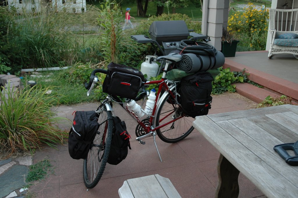
I continued training through May and then had to go to Puerto Rico for field work for a month in June but resumed training in July. I then returned for a week to Puerto Rico prior to coming back for a few days to pack and leave. During my last week in PR, I worked too hard and got too little sleep due to work having not proceeded as well during the summer as it should have (I’ll just leave it in the third person for now). Anyway, when I went for my shakedown ride (fully loaded with all the stuff I will be carrying with me), I felt pretty bad. I felt as if all I wanted to do was fall asleep on the bicycle. I also stopped more and it took me a full two hours longer than normal to complete the same 50 mile route. Hopefully, with better rest, things will go better on the road. On August 6, 2006, I disassembled my bike (racks and fenders had to come off, packed it in a box kindly provided by the guys at Biscari Brothers’ Bicycles and headed to Omaha, Nebraska, Kindly transported by my lovely wife, Tac.

Missouri City

While training, I had the opportunity to observe the small town of Missouri City. This is a small community just off new Highway 210 in the Missouri River bottoms. I pass through this town because it gets me off the larger highway and, at the beginning, it allowed me to bypass a significant hill. I passed through this town maybe 10 or 11 times before I saw the first human being. This is a town that used to depend on river travel then on rail travel when the river boats stopped running. After Highway 210 was built, the town probably depended on it for its livelihood but, with the construction of new Highway 210 (about a mile north of the town), old Highway 210 enters the town on the east but is blocked off by guard rails crossing the road at the west end of the town. I can still travel the old highway by lifting my bicycle over the guard rail and motoring down the thin strip in the middle of the road that remains as vegetation slowly overcomes the asphalt. As Missouri City withers, nature reclaims what was once the dominion of humans and their cars. I wonder how many similar towns, abandoned by river boat and train and truck, I will see withering in the American west as I travel routes opened by Lewis and Clark.

General Observations on Travel

One interesting thing about travel is the people you meet and the conversations you overhear and sometimes become a part of. While sitting in the first class cabin of American Airlines flight 1894, I was amazed at the insanity of how we were being doted on by our flight attendants while people back in coach were paying good money for crackers and peanuts (literally). While there, I overheard one flight attendant say to the other, “Why do I always get all the heart attacks?” She had been looking for the first aid kit (couldn’t find it) because someone back in coach had poison ivy and needed some benadryl. This turned to conversation toward health issues on airplanes. Thus the comment… So being the curious type I asked, “Do you get a lot of heart attacks on airplanes and, while I am asking, are there any free seats back in coach?” The less hazardous of the two and the one who will get me all my drinks for the remainder of the flight replied that they get a surprising number of heart attacks on airplanes but she is sooo glad that we now have in flight defibrillators as if that is supposed to make me feel better considering that the more hazardous flight attendant couldn’t find the first aid kit. And is this really the kind of conversation that the people at headquarters want their flight attendants to be having with passengers. It makes me wonder when they will show the movie Flightplan or Cast Away as the in flight movie.

And, while on the subject of in flight entertainment…American Airlines opts for “CBS Eye on American”. This is basically a long paid advertisement for CBS programs, among them, Entertainment Tonight”. The ET promo is done by Mary Hart. I no longer own a television so I may be overly sensitive but, am I the only person who thinks Mary Hart is one of the scariest chicks around. She talks like she took speech class from William Shatner and her mouth is so large and her gestures so exaggerated that she looks like a bobble head version of a ventriloquist’s dummy.

Now, don’t think that because I am complaining that I have anything against in flight entertainment. I enjoy movies like “Take the Lead” (Antonio Banderas reforms a bunch of inner city kids in detention hall through the magic of ballroom dancing. OK, I slept through it.) and “Dirty Dancing: Havana Nights” (as if the original wasn’t bad enough). In reality, the Mary Hart bobble head beats the hell out of listening to the person sitting next to me outlining her journey to Kansas City as the jumping off point for her combined tour of the Precious Moments Museum and the Laura Ingalls Wilder “biogeographical” pilgrimage. At the time, I thought that woman was pretty unhinged. It never occurred to me that, had I regailed her with my plan to bicycle the Lewis and Clark Trail, she might have regarded me as the unhinged one. After all, she was traveling to Kansas City by plane where she would get in a rental car and drive to the Precious Moments Museum and then set out on the less than 1000 mile trek following the route of the Ingalls family (of Little House on the Prairie fame) throughout the upper Midwest.

I, the truly unhinged, plan on traveling just shy of 3000 miles, unsupported by a sag wagon, on a bicycle, solo. I’ll squeeze the whole route into the 50 days between the end of my field season in Puerto Rico and Septemer 23, 2006 (the 200th anniversary of Lewis and Clark’s return to St. Louis). And I’ll kill three days traveling to Portland, Oregon by train that still puts me 87 miles short of my ultimate starting point, Fort Clatsop in Astoria, Oregon. Part fo this is due to finances (planes being much more expensive) but part is due to the satisfaction I find in working my way down toward a more Lewis and Clark style speed (although I will be covering distance much faster than they did). I traveled by plane (fast modern jet travel) from Puerto Rico to Liberty. I then took a car (relatively fast, modern automobile travel) to Omaha, Nebraska where I boarded the California Zephyr (slow, modern train travel) to take a three day, yes that’s three day, train ride to Portland, Oregon. At that point, I will reassemble my bicycle and start a long trip using the mode of transportation only second slowest to walking in order to make my way back to St. Louis, Missouri.

I have heard it said that one hallmark of the truly insane is their firm conviction of their own sanity.


6 August 2006 – The Journey Begins.

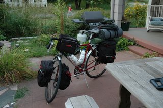
I awoke this morning and went to church for what may be the last time in a while. After church, I packed my bicycle in a used Trek box provided by the guys at Biscari Brothers’ Bicycle in Liberty. The box had straps for securing the bicycle frame to the box and had custom made slots of padding for different parts of the bike. My Fuji Touring is probably feeling pretty cushy under the train right now. I hope it doesn’t expect this kind of treatment always.
After packing my bike, I went to school to clean a lab that my Animal Behavior students and I left pretty trashed at the end of the spring semester. When I returned, I planned to pack my stuff in the car, shower and hit the road with Tac for a leisurely trip to Omaha, Nebraska. Until my phone died. I had a few new messages and when I tried to retrieve them, I got no sound out of the phone. We tried to take it to the Sprint Store in Liberty (hours from 11:00-6:00 on Sunday) but they were closed at 5:00 for an “Area Meeting”. The manager apologized for being closed when they said they would be open but that still left me with no phone. The fact that I was about to embark on a 3000 mile trip without a communication device was immaterial. So much for the “service” we are paying for.

Well, after a start reminiscent of Lewis and Clark’s (3 miles the first day with people left behind who had to catch up, etc.) we were on the road and then everything was better. I got a little more organized while Tac drove and then we talked. We left Liberty at 5:30 and arrived in Omaha at 8:15. We found the train station (easy) and then went to nearby Old Market for dinner. We ate at Vivace, a nice Italian place with me in my convertible pants and William Jewell College t-shirt. After moving away from a young man try into impress his date with how long and loudly he could talk we were seated next to some middle aged women out for “girls night out”. After a loud set of interchanges about why their cell phone cameras took substandard photos and numerous attempts by the more than patient waitress who was serving them, they departed. All in all, a pretty nice meal and a pretty enjoyable time.

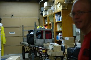
Tac drove me to the train station where I got my tickets and checked my bags. Five dollars extra for the bike. Tac took a picture of me and the boxed bike with the baggage cart in the background. The baggage cart looked like something the settlers might have used on the Oregon Trail (see photo).We walked around a little and then Tac headed home. I got my “boarding pass”. It is basically a piece of paper with my destination, my car number and the number of people traveling with me. I place it above my seat and that “reserves” my seat. It seems an archaic system fraught with potential error but it seems to be working with as few people as are on the train. The train arrived about 35 minutes late and we departed about an hour after we were scheduled to. I got on board and fell promptly asleep.

While I waited, I was exposed to a new version of television. I’ll call it Upper Midwest TV. While the news was on, they of course took time out to give advertisers the opportunity to hawk their wares. While I’m normally expecting pharmaceutical commercials (Hi, I’m Bob Dole…), I was a little amused at their absence. In their place were ads for things like YieldGard Plus Corn and RoundUp Ready Corn 2 (the sequel?) which are of course varieties of corn that have been bred to either withstand pests or withstand common herbicides meant to kill weeds. These products are guaranteed to increase your yield $2-$13 per acre. This should all cause us to wonder at the extremely marginal existence that farming the upper Midwest truly is.

7 August 2006

I woke up at about 7:40 just outside of Denver. We were informed that our route was being changed due to track construction on the west side of the Rocky Mountains. Our route now takes us north of the Colorado Rockies and over the High Plains of Colorado and Wyoming. We pass the Denver Stockyards (photo) and end up at the Denver Union Station. Smokers are reminded that this is a non-smoking train and it will not stop between Denver and Salt Lake City so they had better smoke now. The chief attendant mentions that maybe this is a good time to quit. The up side of this is that we won’t make any of the normal stops and that will put us back ahead of schedule.

After I kind of got myself settled, I called Tac to check in. As we talked, we passed a prairie dog town and shortly thereafter, a herd of about 20 pronghorn antelope. We then saw a herd of bison being raised for meat (the pronghorn and prairie dogs are presumably wild). We also passed a large wind farm blades slowly turning, churning out electricity. We are passing trough a lot of what looks like sagebrush. I have begun seeing lots of magpies and even saw a merlin. I have now seen so many pronghorn that they don’t even warrant mention. The Rockies are far off to the south, blue in the distance.

8 August 2006

Still on the train. The other passengers have located the power outlets. There are three available on the entire train for those of us in coach to use. Competition is fierce. I charge up while I do other things (gawk out the sightseer car) and then take the computer back to my seat to write. I assume that Amtrak designed its cars before the wired age when we all had to plug in ourselves every few hours in order to function. Even Mr. J. Smith (no lie) who works in the lounge car has a PS2 that he is playing with when he is not serving anyone. They also designed their trains when women got a dressing room and men didn’t warrant anything but a toilet and a sink.

Overnight we passed through Salt Lake City arriving 1.5 hours ahead of schedule at 10:30 PM. We were warned not to go into the downtown area (about five blocks from the station) because we might not make it back in time and it was very dangerous. In fact, it was very nice and would have been nicer had anything been open. I needed cold medicine as I have been plagued by a cold since the day I left. So, I headed out. I passed through a nice shopping district that seems to be SLC’s answer to urban renewal and then got directions to the local Maverick from a bicycle cop (very cordial). On the way I found myself across from the Mormon Temple (it was on Temple Street, duh!). Elaborate but smaller than I thought it would be. It was dramatically lit but I really did not have time to take a proper photo. This is also Ground Zero for Mormonism. There are lots of Mormon related buildings in the blocks immediately around the Temple and they seem to own quite a lot of the real estate in the immediate vicinity. I got my goods and headed back to the train and made it with 20 minutes to spare.

At night they show movies in the Lounge Car. This car has large picture windows and t.v.s installed at the end of each car. Lucky for me, they were showing the movie that I purposefully slept through on the plane back from Puerto Rico less than a week ago (Ice Age 2: The Meltdown). I retired to my seat and tried to sleep. Later they were showing Mission Impossible 3 (I think that is the iteration). An hour and forty minutes of Tom Cruise grimacing with determination while everything around him blows up.

I woke up this morning at 7:40 somewhere east of Winnemucca, Nevada. We were going through sagebrush country and then entered a valley that was covered in wetlands in what is essentially a desert. It was such a startling contrast to the surropunding terrain – bright green areas right next to brown to sage green areas with a pale blue sky and parched brown hills in the distance. A river was running through the valley and I saw a plethora of wildlife in and around it. White pelicans silhouetted against the blue sky; western and pied billed grebes diving in the pool; coots paddling around; great blue herons and other egrets fishing in the shallows. Wonderful! I wanted the train to stop so we could walk around.

About 30 mile later, we came to the town of Winnemucca, Nevada. The Amtrak Station looks like one of those bus shelter cities use with stick on lettering like you get at your local hardware store spelling out “AMTRAK STATION WINNEMUCCA, NEVADA”.

It is strange how, on a train, you never really know exactly where you are at any given point without the familiar landmarks of road signs and mileage markers. You have to give yourself up to the rhythm of the train and a slow rhythm that turns out to be. Space begins to be meaningless. What matter most is that occasionally it stops and you can get out and stretch your legs, fill your lungs with fresh desert air and for some, fill up your lungs with cigarette smoke. Amtrak is a non-smoking environment!! Lots of people got off. Smokes were lit. Surprisingly, some people got on. I took some photos and they called for “All Aboard” and off we went, now some 3-4 hours behind schedule.

When I was growing up and watching westerns on t.v. on Saturday afternoon, the train conductor or station manager was always checking a nice shiny gold pocket watch on a nice shiny gold chain as if the checking in and of itself would make the trains run on time. And it seemed that the only time they ran late was when some nefarious outlaw waylaid them in route. But now I know the significance of the watch checking. They wanted to know precisely how far behind schedule the trains were running.

Lewis and Clark had their won timekeeping troubles. One of their charges was to map the areas they traveled through. This required knowing, in an absolute way, their position. This could only be done by measuring ones longitude and latitude and, in the case of latitude, you needed to know what time it was relative to the time at Greenwich, England. So they brought one of the wonders of the time with them – a wind up chronometer. Unfortunately, sometimes they forgot to wind it and sometimes it stopped even when they did wind it. When this happened, they had to halt their progress and wait for noon at which time they would, as best they could, determine the exact moment of noon based on observations of the movement of the sun. Then, resetting the chronometer, they would take a series of readings that would allow them to calculate their position.

We passed through Reno, Nevada which is on the Truckee, River. It is stunningly beautiful. Clear mountain water coming from snowmelt up in the Sierra Nevadas with people fly fishing and rafting down the river. The train follows the river up into the Sierra Nevadas and then crosses the summit and we start heading down to Sacramento. We passed Donner Lake where the Donner party was stranded for that fateful winter. Thoughts of cannibalism float through my head as I watch some truly memorable scenery pass by the window.

9 August 2006 – Still on the train.

Day three of train travel and it all begins to melt together. We got in to Sacramento last night at about 5:30 and my next train was not scheduled to leave until 11:59 PM. I asked about storing bags and the station agent looked at me like I was the first person to ever ask. As soon as I made the move, everyone else on the train followed suit. After that, I went off in search of food. Since the train station is down near the capitol, things generally close up in the evenings. There is an open air mall (not a strip mall but arranged like a regular mall but open, with awnings) so I headed down there. Ended up eating at the Hard Rock Café mainly because I could get a Guinness. I would have taken in a movie but the timing was al wrong (or so I thought). I walked over to the Capitol building and took a few pictures. Nice but, once again, I thought is would be bigger for a state like California.

I walked back to the train station as everything was closing down. Talked with a woman named Angela who tried to convince me that the predictions in Revelations were coming true and these were the harbingers of the end times. Part of her argument was that we wouldn’t know when the end was coming but that did not stop her from trying to convince me that it was now. Her primary evidence seemed to be that Jerusalem is “surrounded by armies”. I mentioned that it seemed to be surrounded by armies in 1947 and 1967 but the end times did not come. When I asked her what was different about this time and she was hard pressed to come up with any other examples of our impending doom. Oh well. My skepticism is probably another convincing piece of data supporting her claim.

We finally got on the train at 2:00 AM. The people in front of me decided to talk for the next 45 minutes even though most of the rest of our car were trying desperately to sleep. They finally turned in themselves. The train is so crowded that some people did not even get seats. I had gumption and got on early and found a seat. The attendants seemed overwhelmed at the number of people getting on in Sacramento. Evidently, this line at this time of year is very crowded.
This morning I awoke as we were passing Mount Shasta which evidently got a new coat of snow a few days ago. It was pretty. We also passed Upper Klamath Lake which is the largest Freshwater Lake in Oregon. It is bordered by extensive wetlands and I once again witnessed lots of waterfowl including those mentioned before and a black crowned night heron. I have never seen so many grebes in one place. Strangley, although the lake is the largest, it is also the most shallow reaching a maximum depth of only 12 feet. This is partly due to the particulars of its formation and the fact that all the tributaries that feed it no longer flow into the lake and it is slowly drying up.

We are making our way north to Oregon and then will cross the state to get to Portland. I suspect we will get there sometime around 6:00 or 7:00 this evening which means I will overnight in Portland and try to get up tomorrow morning early and make it to Fort Clatsop in a day. I will then try to make it back to Portland and then on to Hood River by Saturday because my friend Aaron Shiels is going to a wedding there and I hope to hook up with him.

Currently at least 4 hours behind schedule. I will probably shed public transportation after this train ride and make it the remainder of the way on the bike. I am getting antsy to be on the road and don’t really want to be cooped up on a train or a bus any longer.